In unceded Pacheedaht Territory, on southern Vancouver Island, one of the most spectacular ancient rainforests is threatened by clearcut logging. Despite decades of protests and blockades, Kaxi:ks [pronounced ka-hecks], or the Walbran Valley, remains largely unprotected.
In late 2014, flagging tape was discovered in the old-growth forest of the central Walbran Valley and concerned citizens feared they were marking out proposed cutblocks.
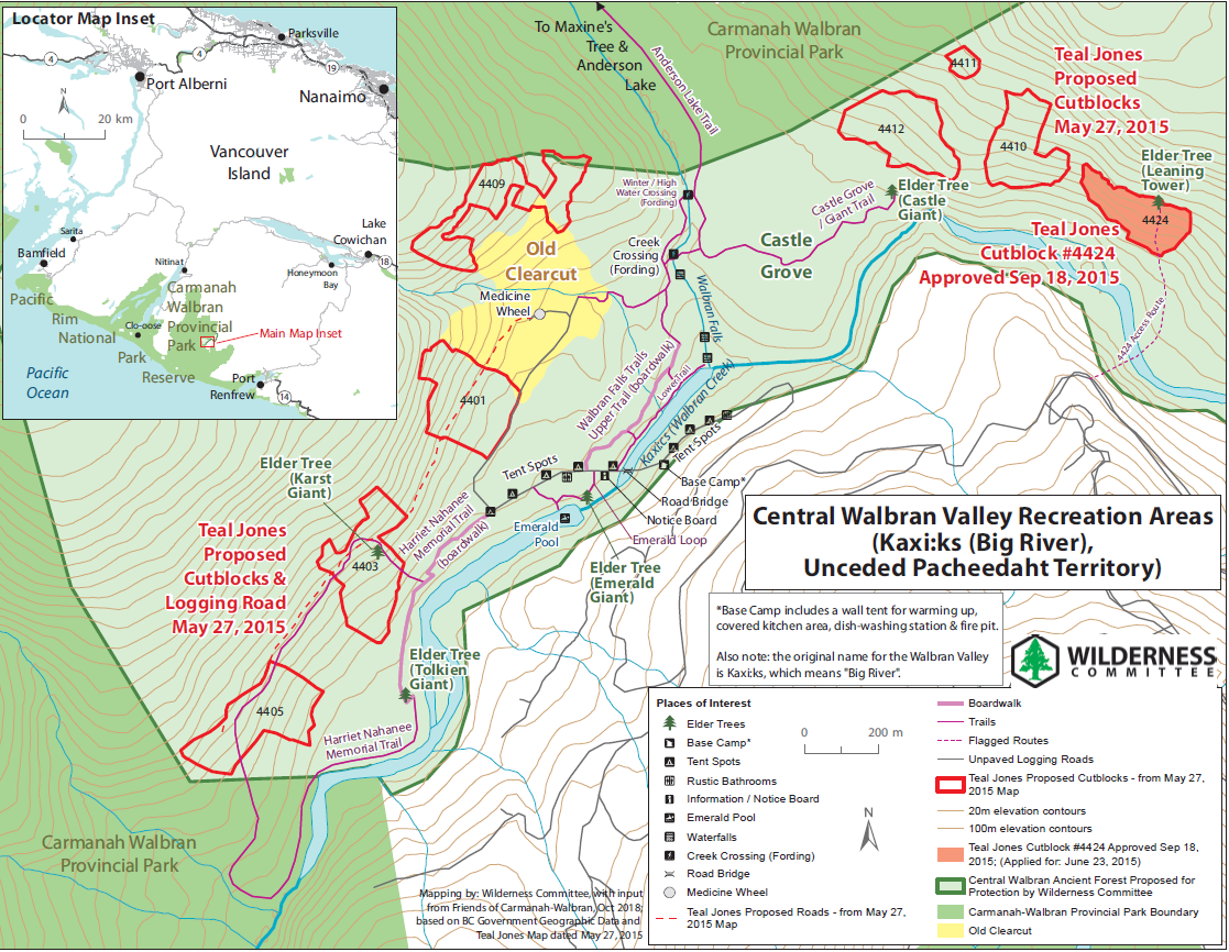
A few weeks later, we obtained maps from the company showing that they were indeed planning to log eight cutblocks of the ancient forest surrounding the iconic Castle Grove.
Now the fight is on to save the remaining ancient forests in this beloved valley.
This is an area close to home for the Wilderness Committee – in 1988, we launched a nationwide campaign to preserve the neighbouring Carmanah Valley. Our volunteers built hiking trails into the heart of the Carmanah Valley and its now world-famous Sitka spruce groves.
In the early 1990s, the BC government responded to this campaign and protected the Carmanah and part of the Walbran Valley – but much of the most ecologically important and recreationally significant rainforest was excluded and left open to clearcut logging.
The Wilderness Committee continued the campaign to preserve the entire Walbran Valley and in 1998 we set up a rainforest research station in the central Walbran Valley near Walbran Falls. Since then, concerned people like you have continued to expand the trail system in the central Walbran Valley through a popular grove of ancient red cedar trees, known as the Castle Grove.
We need you to write our provincial decision-makers and demand protection of the Walbran Valley.
The central Walbran Valley also represents the tip of the iceberg in British Columbia – a symptom of a much larger problem. The vast majority of original rainforest on the coast has already been logged, and despite this, corporations still cut down the equivalent of 34 soccer fields per day on Vancouver Island alone!
Click here to sign the petition demanding the BC government protect remaining old-growth forests and invest in sustainable second-growth forestry that respects the rights of Indigenous peoples and prioritizes local jobs and forest communities!
Please do not visit Kaxi:ks right now, due to risk of spreading COVID-19.

Click to download a map of central Walbran Recreation areas
Click to download a map of Intact and Threatened areas in the central Walbran Valley
Google Map of Recreation Areas & Proposed Logging Cutblocks in the central Walbran Valley
Logging company Teal Jones' approved cutblock #4424 is shown in purple-red and seven other proposed cutblocks (with cutblock ID numbers labelled) are shown as red polygons. The proposed logging road extension is shown in a thicker red line. Trails in the area are shown as thin purple lines, boardwalks shown as thick purple lines, flagged access route to cutblock #4424 shown as a purple-red line, and proposed Castle Grove loop trail shown as a yellow line. Important points of interest are displayed as various icons and can be clicked for more information, including big 'Elder' trees (tree icons). The thick dark green line shows the newly updated boundary of Carmanah Walbran Provincial Park (updated March 31, 2015). The lightly shaded light green area is the Central Walbran Ancient Forest that is being proposed for protection by the Wilderness Committee. The legend can be shown by clicking on the icon at the top left inside the map. For a comprehensive full map with legend, please click on "larger frame" icon at the top right corner of the map.
Your much appreciated donation keeps this work going!
Get in on the action and make a difference!
Help spread the word!

